
What Sits Between the Strait and the Strait
Chokepoints dominate Indo-Pacific analysis. The corridor connecting them is often overlooked.
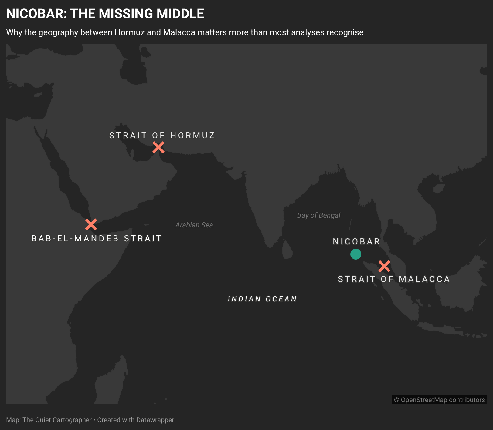
Most discussions of the Indo-Pacific begin with chokepoints.
Strategic analysis has a bias toward interruption. The Strait of Hormuz dominates conversations about energy security. Bab al-Mandeb features in analyses of Red Sea instability and the Suez Canal’s viability as an Asia-Europe trade corridor. The Strait of Malacca — through which more than 100,000 vessels transited in 2025, carrying an estimated 25–30 percent of global maritime trade and roughly 80 percent of China’s oil imports — sits at the centre of almost every discussion about East Asian vulnerability and great-power competition.
Taken together, these locations form the mental map through which most analysts read the Indo-Pacific. The conversation moves from one bottleneck to the next, tracing the routes through which oil, goods, and influence must eventually pass.
Yet this framing obscures one of the most consequential pieces of geography in the region — and in doing so, it misrepresents how maritime power actually works.
Between the Gulf chokepoints and the Strait of Malacca sits the Andaman and Nicobar archipelago. It occupies one of the most structurally significant positions in the wider Indo-Pacific corridor, yet it rarely appears as a strategic variable in its own right. It is discussed occasionally as an Indian naval asset, or as the location of an ambitious development project. More often, it disappears from the analysis entirely.
That disappearance is not incidental. It reflects how the question is being asked.
The Indo-Pacific is not simply a collection of chokepoints. It is a corridor. And corridors possess a different strategic logic — one that the dominant frameworks are not designed to surface.
Chokepoints and corridors are not the same thing
A chokepoint is valuable because it constrains movement. It is a place where traffic concentrates to a narrow passage, where disruption becomes possible and leverage concentrates. Chokepoints attract analytical attention because something dramatic can happen there: a closure in Hormuz affects oil markets; attacks near Bab al-Mandeb force vessels to reroute around the Cape of Good Hope, as happened across 2024 when Houthi strikes cut Suez Canal container transits by more than 60 percent and added up to $1 million per voyage in rerouting costs.
A corridor is valuable because it concentrates movement over distance. Its significance accumulates through presence, logistics, and access — not through the threat of interdiction. Corridors do not attract attention because something happens there. They matter because so much else depends upon them.
A state positioned near a chokepoint may possess leverage during a crisis. A state positioned within a corridor acquires something more durable: persistent proximity to flows that cannot easily relocate elsewhere. The strategic value lies not in the capacity to interrupt but in awareness, staging, and endurance.
This distinction explains why the Andaman and Nicobar archipelago is so routinely overlooked, and why overlooking it produces a distorted picture of Indo-Pacific strategy.
The geography itself is worth locating precisely
The Andaman and Nicobar chain stretches roughly 590 kilometres across the eastern Bay of Bengal, forming a natural boundary between the Bay of Bengal to the west and the Andaman Sea to the east. Its southernmost point, Indira Point on Great Nicobar Island, lies approximately 145 kilometres — 80 nautical miles — from Rondo Island in Indonesia’s Aceh province. It sits roughly 1,843 kilometres from Chennai on the Indian mainland.
This is not a remote outpost on the edge of Indian territorial waters. It is a forward maritime position, located across the western approaches to the Strait of Malacca. Ships moving between the Indian Ocean and East Asia — the 102,525 vessels that transited Malacca in 2025 alone — do not simply appear at the strait’s entrance. They travel through a wider corridor linking the Arabian Sea, the Bay of Bengal, and Southeast Asia. Nicobar sits inside that corridor.
Strategic analysis often describes the islands as remote because they are distant from mainland India. Yet maritime geography is measured differently. Great Nicobar is not close to Delhi; it is close to the traffic that matters. What appears peripheral on a continental map sits central when read through the geometry of maritime trade.
Position within a corridor creates three structural advantages — each of which operates independently of any declared posture or political signalling: awareness, logical depth, and autonomy.
Awareness
Modern maritime competition revolves less around interdiction than around information. Understanding shipping patterns, monitoring movements through AIS tracking and signals intelligence, and maintaining domain awareness across a maritime corridor often matters more than the capacity for direct action. The actor with the clearest picture of corridor activity acquires advantages long before any crisis emerges — in trade resilience assessments, in early warning of grey-zone activity, in the ability to distinguish pattern from anomaly.
Nicobar’s significance begins here. It provides visibility across the western approaches to Malacca, not because it controls the strait, but because it occupies the space through which traffic is already distributed. Maritime influence rarely begins at the chokepoint itself. It begins with awareness of the broader approaches leading into it.
Logistical depth
Distance is one of the defining constraints of maritime power. Sustained presence requires maintenance, resupply, infrastructure, and communications. States seeking an extended maritime footprint have historically solved this problem through overseas bases or negotiated access agreements with partner governments. Those arrangements carry value, but they also introduce dependencies. Governments change. Political priorities shift. Access can become contested or conditional.
Geography within sovereign territory solves a different problem. The Andaman and Nicobar Islands allow maritime reach to extend eastward while remaining anchored in domestic jurisdiction — without requiring external negotiation, without creating leverage for a partner state to withdraw cooperation. This does not substitute for partnerships; it reduces the degree to which strategic presence depends upon them. In geopolitics, advantages often emerge less from creating new options than from reducing dependencies.
Autonomy
The third advantage is autonomy — the capacity to enable cooperation without triggering the full range of political costs that formal basing arrangements typically carry.
Maritime presence is often discussed in terms of ships, ports, and naval capacity. Less attention is paid to the political infrastructure that sustains access. Throughout modern maritime history, states have extended their reach through overseas bases, access agreements, and host-nation arrangements. These can provide considerable advantages, but they also introduce dependencies. Access is negotiated, renewed, contested, and occasionally withdrawn. Political change in one country can alter the strategic assumptions of another.
The significance of the Andaman and Nicobar Islands is that they provide depth within sovereign territory. Their value lies not only in what they make possible, but in what they reduce the need for. Presence, surveillance, logistics, and maritime coordination can be developed from geography already under Indian jurisdiction rather than relying entirely upon external arrangements. This does not eliminate the importance of partnerships, nor does it replace the role of regional cooperation. It simply means that some forms of strategic access rest upon geography rather than permission.
In this sense, Nicobar represents a form of maritime autonomy. The advantage is not control over other actors. It is a reduced dependence upon them.
Increasing relevance
The relevance of these functions has grown as pressure accumulates at both ends of the corridor.
Since late 2023, Houthi attacks on commercial shipping drove a more-than-50 percent decline in vessel transits through Bab al-Mandeb. Container spot rates from Asia to Europe surged nearly fivefold from their pre-crisis levels. Asia-Europe transit times extended from 35 to 49 days as vessels rerouted around the Cape of Good Hope. These disruptions demonstrated, at considerable cost to global supply chains, that the Red Sea corridor — through which approximately 12–14 percent of global maritime trade ordinarily flows — could be rendered effectively non-functional by a non-state actor with relatively modest capabilities.
At the eastern end of the same system, tensions around Taiwan and competition in the South China Sea have sustained attention on the first island chain and the maritime approaches to East Asia. China’s exposure is structural: with roughly 80 percent of its energy imports transiting Malacca, the Malacca Dilemma — the vulnerability of a single narrow chokepoint — remains unresolved despite decades of investment in alternative land corridors and port infrastructure across the Indian Ocean littoral.
These developments are typically analysed as separate theatres. They are not. They are stresses on the same underlying corridor — the maritime system that links the Gulf, the Bay of Bengal, Southeast Asia, and East Asia into a single connected space. As pressure accumulates at both ends, the stability and positioning of the geography that connects them becomes more consequential, not less. The corridor does not become less relevant because the endpoints are volatile. It becomes more so.
Seen in this context, the Great Nicobar development project — formally the Holistic Development of Great Nicobar Island, approved in 2021 at a projected cost of $8.6 billion to $9.7 billion USD — appears less as the source of the islands’ strategic significance and more as recognition of it. The project’s core components include an International Container Transhipment Terminal at Galathea Bay targeting an ultimate capacity of 14.2 million TEUs, a dual-use international airport, a township, and a 450-MVA power plant. The port sits approximately 40 nautical miles from the international East-West shipping route. Phase one is targeted for completion around 2028 at a cost of approximately $1.89 billion USD, handling 4 million containers annually.
The geography existed before the project. Infrastructure can amplify a structural position but cannot create one. States build infrastructure where they perceive enduring geographic value. The scale of the project is itself evidence of that perceived value.
This is why the omission of Nicobar from most Indo-Pacific analysis reveals something about analytical frameworks, not just about the islands.
Energy-security frameworks naturally emphasise Hormuz. Analyses of Red Sea disruption emphasise Bab al-Mandeb. Discussions of Chinese vulnerability emphasise Malacca. Each framework captures something important and each is well-suited to answering the questions it was designed for.
Together, though, they encourage a view of the Indo-Pacific as a sequence of strategic bottlenecks separated by passive ocean. The region appears as a set of crisis points, and strategy appears as the management of those crises. What such a view cannot surface is the geography that connects the bottlenecks — the corridors through which presence is sustained, where awareness is developed, and where the conditions for future action are set.
The Andaman and Nicobar archipelago occupies one of the most structurally important of those corridors. It is not absent from the map. It is absent from the frame through which the map is usually read.
To see it is not to add another point to the Indo-Pacific. It is to read the Indo-Pacific differently.
Follow on X: The Quiet Cartographer
References
Strong framing. The distinction between chokepoints and corridors is also a distinction between episodic coercive leverage and persistent operational optionality.
Geography, however, becomes power only when it is converted into an architecture of sensing, logistics, access, and decision-making. Great Nicobar’s value therefore lies less in “controlling” Malacca than in shortening the chain from awareness to sustained action across the wider maritime system.
That also raises a resilience question: once strategic functions are concentrated in a major infrastructure hub, geographic advantage can become a new dependency unless those functions are distributed, hardened, and redundant.
One small numerical point: the project-cost range appears to be off by a decimal place; the commonly cited figure is approximately $8.6–9.7 billion, rather than $86.4–97.2 billion.
Good one. You elucidated it well and I get your point on the broader Geography from the earlier conversation.
Here is the irony, atleast for me. From the Roman times and into the 19th century, it was always the concept of Indian Ocean trade that drove the thinking. Isn't this whole Chokepoints a more recent outcome?
The Portugese. The Dutch and the British looked at the whole expanse, starting with Persian Gulf and Red Sea to the South China Sea as one continuum.
Probably it is time to learn some lessons from history, which we never seem to